K-5 students have learned to recognize tides, count wave sets, sort beach sediments. Students have made observations about weather and water. Students in 5th grade collected beach sediment, discussed its components and examined sediments with microscopes.
Students in 6-8 have participated in a 6 week monitoring program at Onekahakaha Beach Park. They collected data including gps, tide, weather observations, cloud coverage. They used anemometers to measure wind speed, air temperature, humidity and dew point. Students collected water quality data including pH, salinity, dissolved oxygen, and temperature using refractometers, thermometers, pH meter, and YSI conductivity meter. Students distinguished difference in water perameters between marine sample sites and estuarine sample sites. Students formed hypothesis, collected data and formed conclusions about watershed processes that effect the intertidal zone.
Life in the Intertidal Zone
The intertidal zone occurs where land meets sea.
It includes the ecoystem between the farthest reaches
of high and low tide.
Tides, the periodic rising and falling in the oceans height
at a given location, is caused by the gravitational pull of the sun and moon.
Tidal changes in Hawaii are minor compared to places like
Alaska where tides may range 20 feet.
Mixed tides occur along the Pacific Coast, Alaska, and Hawaii.
The intertidal monitoring program will collect data on the follwoing
water perameters in order to gain a better understanding
of how watershed systems effect the intertidal zone.
Salinity
Salinity is the amount of salts in a body of water
Salt enters the ocean from runoff and undersea volcanoes.
Expressed as the amount of salt found in 1,000 grams.
Freshwater salinity is usually less than .5 ppt.
Ocean salinity varys between32 and 37 ppt.
Brackish water salinity varys between .5 and 17 ppt.
Temperature
Temperature is the measurement of hotness or coldness of an substance.
It is measured in Fahrenheit, Celsius, and Kelvin.
Dissolved Oxygen
Oxygen enters ocean from atmosphere.
Plankton produce oxygen during photosynthesis.
DO is used by bacteria during decomposition.
Temperature and salinity affect how much dissolved oxygen water absorbs.
Units for measurement in ppm (parts per million)
Why is DO important?
Ocean flora and fauna require oxygen for respiration.
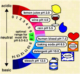
pH
pH measures how basic or acidic a substance is.
It is a measurement of hydrogen ion concentraion.
pH scale range is from 1 to 14.
7 is neutral, pH of freshwater.
The ocean has a pH of 8.


